by Jim Goodman
 |
| typical islands of Hạ Long Bay |
Most of the islands studding
the waters of Hạ Long Bay, Vietnam’s premier scenic wonder, are
small, limestone promontories jutting out of the sea, largely uninhabited. But dominating the southern edge of the
bay, with its own archipelago of 365 islets, mostly on the northern and eastern
sides, lies Cát Bà Island, with the atypical size of 285 square kilometers. Though much larger than any other
island in the vicinity, about half of it is a preserved forest area and the
rest is mostly too hilly and rocky for agriculture. Fishing is the main livelihood of the island’s 13,000
inhabitants and the 4000 or so in offshore floating villages.
 |
| central pier at Cát Bà harbor |
Administratively, the Cát
Bà Archipelago is part of Hải Phòng City, from where boats make daily
trips to the harbor at Cát Bà town, on the southeast corner of the island. Home to about 8000 of the island’s population, the
town lies on a narrow strip of flat land between fingers of hilly land, with
even higher hills right behind it.
Hotels of various sizes (and room rates) dominate the waterfront, for
Cát Bà’s main change in the 21st century has been the growth of the
tourist industry.
Most tourists are part of
groups that spend at least a night in Cát Bà town after coming from Hạ
Long Bay. For those who’ve spent
the previous night in Hạ Long City, it’s quieter, less congested and the
restaurants offer equally delicious fresh seafood. Cát Bà’s great advantage, though, is its harbor. A long
dock, almost in the center of the waterfront, services the big boats coming
from Hải Phòng. Sprawled out on
either side are innumerable fishing boats, usually moored during the day,
interspersed with sampans gliding among them, some with attached roofs, some
without, some fishing with nets.
 |
| boats in Cát Bà harbor |
The land reaches out on either
side of the harbor to partially enclose it. Lighthouses stand on rocky promontories on either side of
the outer edges. On the eastern
side several floating houses lie just offshore. Small hilly islands lie out in the bay. The brightly colored boats in the
harbor can be anywhere from two to twenty meters long. Most are anchored individually, but
sometimes two to ten boats of the same size may lie side by side in a single
row.
The nicest aspect of a harbor
like Cát Bà’s is that, except days of squalls and storms, it is never
completely inactive. The bigger
fishing boats might rest there for a few days without setting out to sea. But you will still see individual boats
go out on their own. And the harbor
scene will always feature the smaller sampans and dinghies gliding around the
boats, taking goods or passengers from the docks to the boats and vice versa. Occasionally you can spot someone rowing
the boat by using his feet to move the oars.
 |
| sampan and tour boat, Bên Bèo |
 |
| fishing vessel and basket boat |
The abundant seas around Cát
Bà Archipelago have nourished its people well over the centuries. In the 1930s French archaeologists
discovered human remains and other evidence indicating that people had been
living on the island since 6000 years ago, perhaps the first human inhabitants
of the offshore territory of northeast Vietnam. It was never heavily populated, nor an important factor in
the economy or commerce of the area.
When, during the period of Chinese rule, marine trade began to develop,
the focal point was Văn Đồn Island, far from Cát Bà.
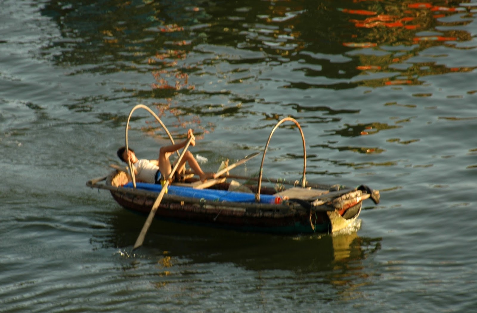 |
| rowing with the feet |
The old historical records,
Chinese or Vietnamese, make no mention of Cát Bà. There must have been some sort of government authority, but
probably not enough to interrupt the basic self-sufficient lifestyle of its
people. One can only speculate on
what role they might have played in the great historical events in the
area. Were they aware of the
invading Chinese fleet in 938, dispatched to quell the rebellion led by Ngô Quyền,
that ended with the fleet impaled on hidden stakes in the Bạch Đằng River?
A generation later, did they
witness the newly established Song Dynasty’s fleet sail into Hạ Long Bay and
get stuck on the same stakes in the same place? Did they observe the third Mongol invasion in 1288 as its
ships swept aside resistance and sailed upriver to the capital? Were any of them recruited to join the
rebuilt Vietnamese navy that later sank all the Mongols’ supply ships and
forced their evacuation of the country?
Did any of them participate in the third trick on the Bạch Đằng, when
the Vietnamese impaled the retreating Mongol ships on hidden stakes, burnt all
the vessels and slaughtered all aboard?
 |
| one of the Cót Cô baches |
There doesn’t seem to be any
local legend about Cát Bà heroes in the Trần Dynasty’s Mongol Wars. But the island’s name dates to an
incident from that time. According
to local tradition, the corpses of three women, killed for one reason or
another, each washed ashore on one of the three small beaches on the southeast
corner of the island. Local residents
retrieved them and built temples to them.
Whatever its name was before, from then on the island was Cạt Bà. In Vietnamese cát means ‘sand’ and bà means
‘woman.’ Cát Bà is short for ‘women
landing/washing up on the sand.’
All three of these beaches—Cót
Cô 1, 2 and 3--are popular with visitors, for they are within walking distance
of the town, connected by a cement walkway along the rocky coast. They are relatively small, but with
fine sand, clean and clear water and views of the Lan Hạ Bay islands. From March through October, if the
weather is fine, they can fill up with weekend or holiday visitors from the
mainland. Temperatures are too
cool the other months for swimming or sunbathing, and visitors fewer, but it’s
rarely cold and usually a few degrees warmer than inland.
 |
| cheô drama in the Cát Bà park |
The most crowded time will be
around 1 April, the day commemorating Hồ Chí Minh’s 1954 visit, marked by Cát
Bà’s biggest annual festival. The
program includes processions, boat races and public performances. In the park near the harbor’s long
pier, troupes stage skits from the indigenous chèo drama and Chinese-derived tuồng
opera. Theatrical shows also take
place in the park on other local and national holidays.
The island’s weather can be
quite changeable, though, starting out with clear morning skies and clouding up
and raining by noon. The entire
northeast coastal area and its waters are subject to sudden storms and
occasional typhoons. At such
occurrences boats stay docked at the shores and neither sail to Hạ Long City
nor leave the Cát Bà pier for Hải Phòng.
But it doesn’t mean travelers are trapped until the seas calm. They can take a bus to the west coast,
passing craggy limestone hills that look good even in the rain, then board a
hydrofoil for a quick ride across the channel to a waiting bus on the mainland
that goes all the way to Hanoi.
 |
| Chicken Rocks, Hạ Long Bay |
In reverse, that’s actually a
quicker way to reach Cát Bà from Hanoi than to go first to Hải Phòng and take a
boat. Weekend visitors from Hanoi
often choose this option, but the far more interesting route is from Hạ Long
City across the World Heritage Site (since 1994) of Hạ Long Bay. The inexpensive morning ferry service
from nearby Hòn Gài ceased several years ago and so now the only option is to
hop one of the dozens of fancy tour boats. In general they are attractive vessels, though, with redwood
sides and pale yellow sails, resembling the warships that traversed these
waters in the centuries before boats had engines.
The first boats leave about 11
a.m., while others wait an hour or two later for the tour buses to arrive from
Hanoi. They follow similar routes,
though some range further than others.
Hạ Long Bay has nearly 2000 islets, mostly limestone, small, fairly
close to one another, usually uninhabited, often jutting straight out of the
water with steep vertical cliffs, or with shapes suggesting animals, like the
pair of Chicken Rocks (also known as the Kissing Cocks).
 |
| floating village, Hạ Long Bay |
 |
| typical island karst cave |
Several islands feature big
karst caves and every tour boat makes a lengthy stop at one of them. It takes nearly an hour to hike up and
down walkways past all the stalagmites and stalactites, illuminated by
different colored lights all along the way. The most famous is Đầu Gỗ Cave, allegedly a secret storage
site for the wooden stakes the Vietnamese planted in the Bạch Đằng River to
impale and immobilize the Mongol fleet.
Continuing south, the boat
will pass by one of the larger floating villages in the bay, nestled among the
islets. The villagers have their
own modest fishing vessels, but they also raise shrimp and other edible sea
creatures. Some of what they raise
or catch goes to the kitchens of the tour boats. After passing by still more islets the boat eventually docks
at the Gai Luân pier on the northern part of Cát Bà Island.
 |
| Lan Hạ Bay, viewed from Cannon Fort |
From here travelers take a bus
across the center of the island south to Cát Bà town. The road passes through Cát Bà National Park, a huge
preserved area of forested limestone hills, lakes, mangrove swamps and
incredible biodiversity. Altogether
the park holds 1561 species of plants and trees, 55 mammals, including the
endangered Cát Bà langur, of which only about 70 are left, 160 different birds,
66 reptiles and amphibians and 274 insect species. The parks waters contain 900 species of fish, 167 of coral
and even 21 kinds of seaweed.
Further towards Cát Bà town,
about 10 km north, is the most famous of the island’s several caves. It’s called Hospital Cave, because
that’s what it was used for during the war with America. Nearby Hải Phòng was a prime target
during the periodic bombing campaigns.
As a strategic lookout point in the north’s defenses, the bombers hit
Cát Bà also. Residents hid in the
caves for safety. Hospital Cave
was built up with three levels and could hold over three hundred beds in what
was virtually a bomb-proof shelter.
Perhaps fearing a possible resumption of the bombing even after the
American withdrawal began, the hospital remained operational until the end of
the war in 1975.
While Hospital Cave can be a
quick excursion, it takes a lot longer to trek through the park. Motorbikes, unfortunately, are not
allowed inside the park. But it’s
worth renting one from town for a ride around the southern side of the island. The roads are good and the scenery
always pleasant and changing. West
of the town is much less settled, a quiet countryside with occasional small
beaches, rugged hills, stray fishing vessels and always groups of lumpy
offshore islands.
 |
| boats passing through Lan Hạ Bay |
Even lovelier is the southeast
corner of the island, from Cát Bà town around the edges of Lan Ha ̣Bay to the
wharf at Bên Bèo. This is a
starting point for kayaking trips through the bay’s picturesque island scenery. Tour boats take visitors on excursions
to nearby Monkey Island, where you are more likely to experience a simian
encounter than by trying to track down one of the elusive, vanishing langurs in
the National Park. Bên Bèo itself
is a charming, quiet village, part of it floating houses, with a couple
excellent restaurants along the docks and an active river scene.
With its collection of closely
clustered islands in an endless variety of shapes, Lan Hạ Bay is like Cát Bà’s very
own Hạ Long Bay. It may not be
quite as dramatic, but in one sense it is easier to appreciate. A good road leads to Cannon Fort, high
up on a hill overlooking the bay.
During the war years this was obviously an important lookout post, where
soldiers nervously scanned the skies for the approach of planes.
Nowadays we visitors instead
scan the panorama of Lan Hạ Bay. We
watch the tour boats and fishing vessels glide among the islands and the big
cargo ships sail around the rim of it.
Cannon Fort has long been abandoned. The main task around here now is to revel in the splendid
natural combination of sky, land and sea.
 |
| Cát Bà harbor |
* * *
No comments:
Post a Comment